Site 54: Pakenham Fen and the EDF
In January 2021 Pakenham Fen made its way onto an unenviable short list: wetland sites chosen by Électricité de France as being suitable for making good the damage done creating their new nuclear power station at Sizewell. Their mitigation plans do not appear to have taken into account the vital role of the unassuming watercourse that buddies the main Pakenham Stream.

Pakenham Fen is fairly flat – we are in Suffolk after all – and so to create a head of power and using hand tools alone, the people of Pakenham engineered not only an elevated channel for the water and Mill Pond, but incredibly built in a failsafe mechanism to bypass the head of water collecting in front of the Water Mill.
“There has been a watermill in Pakenham for almost a thousand years, and for all that time millers on this site have been using the simple technology of water power to produce stone-ground wholemeal flour for local people. Owned today by the Suffolk Building Preservation Trust, a team of dedicated volunteers continues this long tradition.” https://pakenhamwatermill.org.uk/
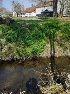
If you are standing on the bridge with your back to the Mill on the right is a small stream much lower than the main Pakenham Stream.
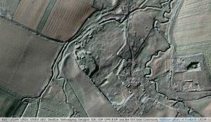
Can you trace its path on this Lidar map?
The view is looking south towards the Fen, and the flow is north towards the bridge. The water flowing to the Water Mill is there on the left.
The Lidar map shows how the constant flow of water over the centuries has etched its way into the landscape.
The original stream disappears under the Fulmer Bridge on Thieves Lane and pops up for a short distance before being channelled under the WaterMill’s clay-lined millpond, and re-appears showing its true chalk stream quality as it runs alongside bypassing the Mill’s pond and Sluice.
chalk stream bypass heading north towards MickleMere
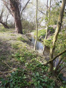
chalk stream channel flowing alongside the watermill lagoon
Having re-appeared near to the picket fence gate on the other side of the Mill Pond, this clear flowing chalk stream carries on its journey passing the sluice on its left-hand side and then under the road Mill Lane to meet up with the Stowlangtoft Stream [previously called the Black Born] and swells to become the Sapiston river in Ixworth.